Webinar | Geomatics: The Key to Smarter, Safer & More Efficient Digital Transformation in Engineering Projects
Register by April 23, 2025
Geomatics engineering is transforming engineering projects by bridging the gap between physical reality and digital innovation. Through advanced reality capture technologies such as mobile mapping, UAVs, LiDAR, 3D scanning, and conventional surveying, geomatics engineers create highly accurate digital twins that serve as the foundation for projects in energy, transportation, infrastructure, power delivery, rail, and more.
This session will explore how geomatics integrates cutting-edge hardware, software, and AI-powered workflows to transform massive datasets into actionable, high-value information—keeping your data and project in one place. We’ll also discuss why a strong, well-managed control network is essential for maintaining data integrity and project success. By ensuring engineering-grade quality, geomatics empowers all engineering disciplines to achieve smarter, safer, and more efficient project outcomes.
Join us to discover how geomatics is driving digital transformation and enabling innovation, data quality, and project efficiency across the engineering landscape.
Brought to you by the Edmonton Branch. Everyone is welcome to attend.
For any questions about this event, please contact [email protected].
About the speaker
Mohamed Attia, P.Eng., PhD, PMP,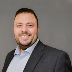 is a professional geomatics engineer with more than 20 years of professional experience. Mohamed Attia has a diverse international industrial and academic portfolio. His broad expertise includes managing and supervising major geomatics projects, operations management, geospatial projects and solutions, advanced technology implementation and applications, geospatial data modelling, management and analysis, and business development. His past work experience includes significant energy projects, infrastructure projects, pipeline integrity and construction, geodetic control networks, navigation applications, and map production.
is a professional geomatics engineer with more than 20 years of professional experience. Mohamed Attia has a diverse international industrial and academic portfolio. His broad expertise includes managing and supervising major geomatics projects, operations management, geospatial projects and solutions, advanced technology implementation and applications, geospatial data modelling, management and analysis, and business development. His past work experience includes significant energy projects, infrastructure projects, pipeline integrity and construction, geodetic control networks, navigation applications, and map production.With a PhD in geomatics engineering from the University of Calgary and a master of science, GIS and surveying engineering from Ain Shams University, Cairo, Egypt. Mohamed’s educational background makes him a well-rounded member of the GeoVerra leadership team.
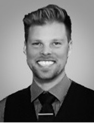 Dene Gott, P.L. (Eng.), P.Tech. (Eng.), PMP, graduated from Lethbridge College in May 2004 with a diploma in geomatics engineering technologies. Over his career, Dene has worked in the oil and gas industry, major civil earthwork projects (e.g. earth dams and road construction), power infrastructure industry, and large industrial projects. He is currently working as the director of industrial surveys at GeoVerra, where he oversees a team for the support for major industrial projects. This includes utilizing new technologies, such as UAV, augmented reality, 3D scanning, and photogrammetry, to assist with the construction and asset management of facilities. He is a member of the Association of Professional Engineers and Geoscientists of Alberta (APEGA), the Association of Science & Engineering Technology Professionals of Alberta (ASET), and the Project Management Institute (PMI), and holds a Basic Drone Pilot Certificate in Canada.